Louisiana prepares to help neighboring states as Hurricane Sally creeps closer to landfall
From CNN’s Laurie Ure
Louisiana Gov. John Bel Edwards said his state is transitioning to help its eastern neighbors in Mississippi and Alabama, conceding the "good news" that Hurricane Sally is tracking east of projections that put his state in the storm's bull's eye some 48 hours ago.
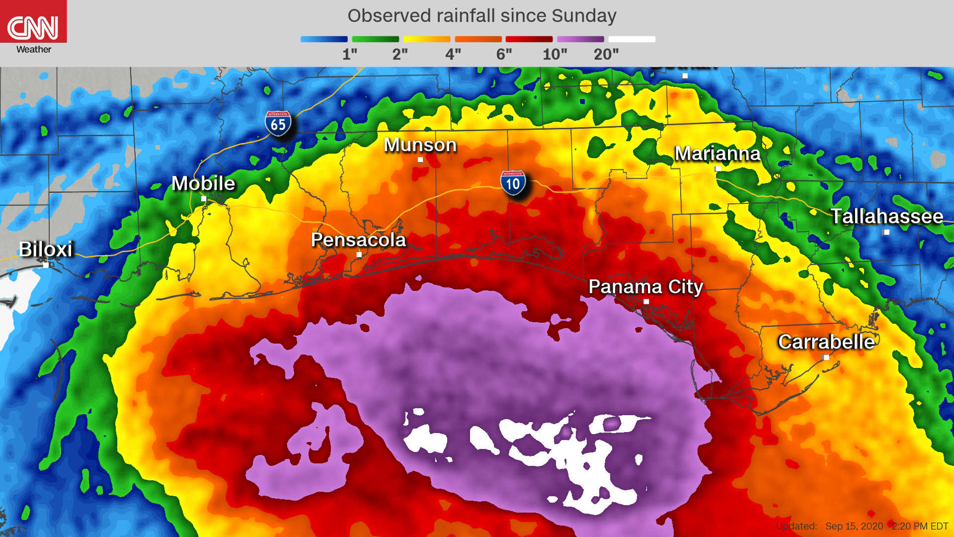
Ten to 20 inches of rain are expected along the Gulf Coast, with isolated higher totals of 30 inches possible from western Florida to southeastern Mississippi coast, CNN reports.
Edwards said he spoke with the governors of Mississippi and Alabama and told them his state stands ready to assist, adding that some rescue assets from the Federal Emergency Management Agency in Louisiana have already been redirected to Anniston, Alabama.
Louisiana continues to recover weeks after Hurricane Laura ravaged parts of the state, where some parishes are still without power and some residents remain homeless, the governor said.
As for Hurricane Sally, "All in all, we'll take the storm as she is, rather than one that was forecasted couple of days ago," he said.
Heavy rain and wind pound Gulf Shores, Alabama
From CNN's Amanda Jackson
Hurricane Sally is slowly crawling toward the US Gulf Coast border, dumping heavy rain along parts of Alabama and Mississippi along the way.
The National Hurricane Center has warned that "historic life-threatening flooding" is likely along parts of the Gulf Coast.
Heavy wind and rain were spotted Gulf Shores, Alabama, today ahead of Sally's landfall. Here's what it looks like:
Sally brings tornado threat to the Gulf Coast
CNN meteorologist Haley Brink
The tornado threat is increasing across southern Alabama and across the Florida panhandle this afternoon and into the evening hours as Hurricane Sally approaches the coast. The outer bands in the northeastern quadrant of the storm will be the area to watch for the greatest tornado threat.
A slight risk (level 2 of 5) has been issued across this region by the Storm Prediction Center (SPC) and includes Mobile, Alabama, Pensacola, Florida, and Panama City, Florida.
The Storm Prediction Center highlighted that "a few tornadoes" may occur across this region through tonight.
A tornado watch was first issued for portions of southwestern Alabama and the Florida panhandle earlier this morning.
So far, there have not been any reported or confirmed tornadoes associated with Sally.
However, this is likely to change over the next several hours.
"This threat has been limited thus far today, but is expected to increase by late this afternoon and evening as the center of Sally drifts northward," the SPC warned in their discussion.
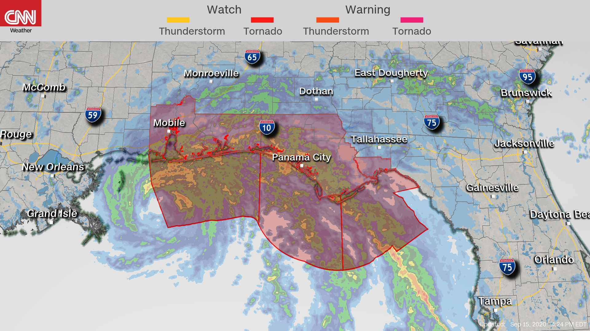
This evening's increasing chance for tornadoes has prompted the SPC to extend the original tornado watch until 6 p.m. CDT. A new tornado watch is likely to be issued after 6 p.m. as the tornado threat will persist through the evening and potentially overnight hours.
Here's what is forecast to happen after Sally makes landfall
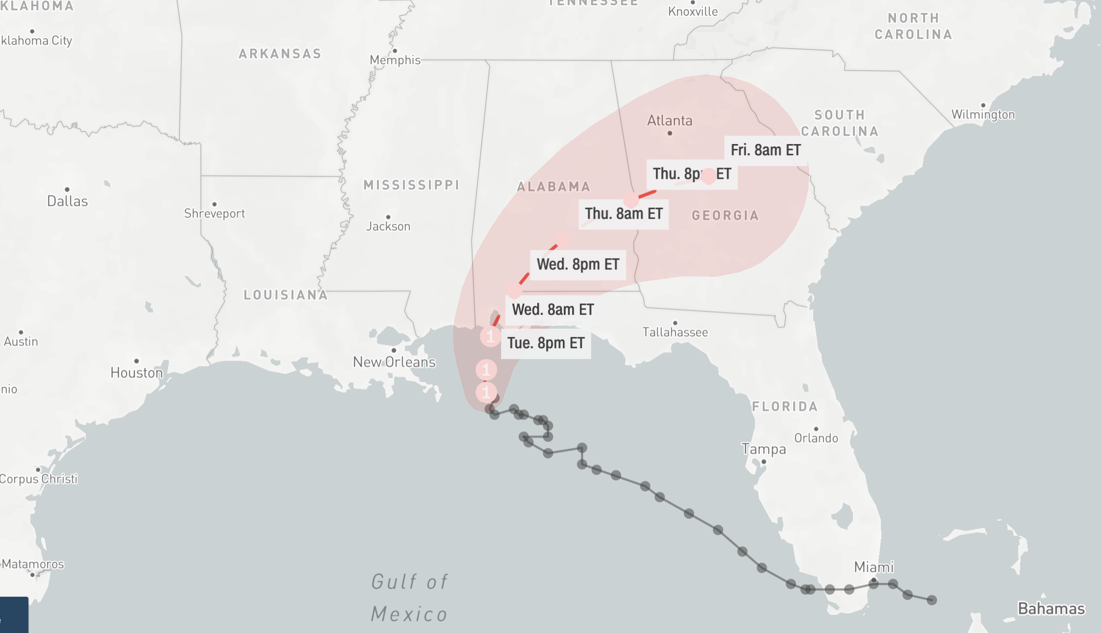
Hurricane Sally has been inching toward the US Gulf Coast today, drenching parts of Alabama, Mississippi and the Florida Panhandle in rain. But the storm has yet to make official landfall.
Sally may not move over land until early Wednesday.
Later tomorrow, Sally is expected to travel northeastward through Alabama. It could then travel through Georgia on Thursday.
Sally could be the first hurricane to hit Alabama in 16 years
From CNN's Brandon Miller
Hurricane Sally is continuing to batter the US Gulf shore, and conditions are expected to worsen through the day and night as the storm creeps towards land.
Sally is currently located about 75 miles south of Dauphin Island, Alabama.
If Sally makes landfall in Alabama, it will be the first hurricane to make landfall in the state since Hurricane Ivan in 2004.
Half a foot of rain has already fallen
Sally hasn't made landfall, and the heaviest rain hasn't even made it onshore.
Yet, widespread amounts of four to more than six inches of rain have already fallen from Sally over the past 48 hours, according to radar data.
In the image below, you can see just how much has fallen.
Sally could hit the US with tropical storm-force winds for 30 straight hours
From CNN's Brandon Miller
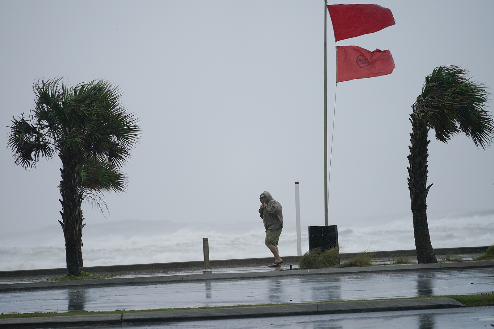 A man walks bear the gulf as Hurricane Sally moves in on Tuesday in Gulf Shores, Alabama. Gerald Herbert/AP
 Sally is currently moving at 2 mph, slower than an average human walking pace of 3 to 4 mph.
As Sally crawls toward shore, tropical storm-force winds — winds 39 mph or higher — could be experienced for more than 30 hours in the areas where the storm will be making landfall.
Winds have already begun from the Mississippi/Alabama border east into extreme Western Florida. They're expected to last until Wednesday night.
"Historic life-threatening flooding likely" along parts of the Gulf Coast, forecasters warn
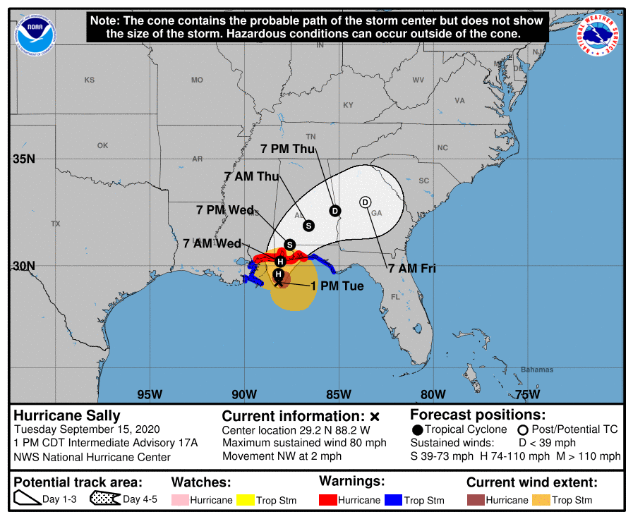
Hurricane Sally is crawling toward the US Gulf Coast, and it is now 60 miles east of the mouth of the Mississippi River, according to the National Hurricane Center's 2 p.m. ET forecast advisory.
"Historic life-threatening flooding likely along portions of the northern Gulf Coast," the center wrote in its latest update.
Here's a look at the projected path of Hurricane Sally as it inches toward the coast:
What it's like in Mobile, Alabama, as Sally approaches
From CNN's Jon Sarlin and Gabe Rameriz
Hurricane Sally continues to inch toward the US Gulf Coast, drenching parts of Alabama, Mississippi and the Florida panhandle.
Waves crashed in Mobile Bay as Sally churned off the coast today. Troy Anderson, 51, from was watching from his white Chevrolet Truck.
“I don’t think I’ve seen waves this big before," Anderson told CNN. However, he added that he's "not worried" and doesn't plan to evacuate.
Here's what it looks like in Mobile today:

 5 years ago
906
